


Sverige Topo Kartan

Sverige Topo Kartan चे वर्णन
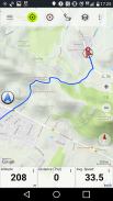
घरातील / बाहेरील वापरासाठी एक GPS नेव्हिगेशन अॅप जो स्विडनसाठी उत्कृष्ट टोपोग्राफिक नकाशे आणि उपग्रह प्रतिमांवर प्रवेशासह वापरण्यास सुलभ आहे.
ऑफलाइन वापरासाठी ++ प्रो कार्ये आवश्यक आहेत! ++
आपल्या सेल फोनशिवाय क्वचितच लोकसंख्या असलेल्या प्रवासासाठी बाहेरच्या जीपीएसमध्ये आपल्या Android स्मार्टफोन / टॅब्लेटचे रुपांतर करा. हे अॅप आपल्याला असे समान मॅपिंग पर्याय देते जे आपण गार्मीन किंवा मॅगेलनच्या जीपीएस हँडसेटसह वापरत आहात.
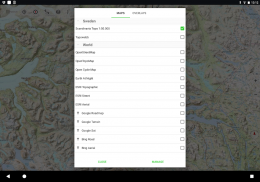
विनामूल्य नकाशा संचयन समाविष्ट करते:
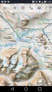
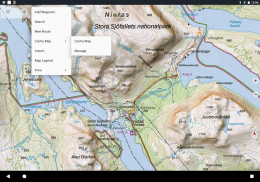
Mountain माउंटन शेडिंगसह स्कँडिनेव्हिया (डेन्मार्क, नॉर्वे, स्वीडन आणि फिनलँड) साठी टोपोग्राफिक नकाशा 1: 50,000 Lantmateriet भूप्रदेश नकाशा + पर्वत नकाशा
. टोपीव्ब: स्विडनचा लॅन्मेटरिएट टोपोग्राफिक नकाशा
• ओपनस्ट्रिटमॅप्स: हे क्राउडसोर्स केलेले नकाशे इतर नकाशे थरांसाठी एक अतिशय उपयुक्त जोड आहेत आणि त्यात अनेक वैशिष्ट्ये आहेत
• ओपनसायकल मॅप्स: हे नकाशे दुचाकी चालविण्याच्या नियमासाठी योग्य आहेत (केवळ पीआरओ वापरकर्ते)
S ईएसआरआय स्थलांतर
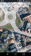
S ईएसआरआय हवाई फोटो
S ईएसआरआय रोड नकाशा
• Google रोडमॅप (केवळ ऑनलाइन प्रवेश)
• Google उपग्रह प्रतिमा (केवळ ऑनलाइन प्रवेश)
• Google भूप्रदेश नकाशा (केवळ ऑनलाइन प्रवेश)
• बिंग रोडमॅप (केवळ ऑनलाइन प्रवेश)
• बिंग उपग्रह प्रतिमा (केवळ ऑनलाइन प्रवेश)
• रात्री पृथ्वी
Rock रॉक शेडिंगचे आच्छादन
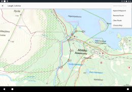
मैदानी वापराच्या नेव्हिगेशनसाठी मुख्य कार्येः
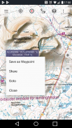
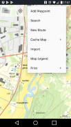
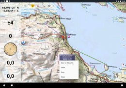
Way वेपॉइंट्स तयार आणि संपादित करा
Way वेपॉईंट नेव्हिगेशनवर जा
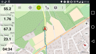
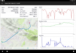
• ट्रॅक रेकॉर्डिंग (वेग, उंची आणि अचूकतेसह)
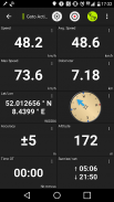
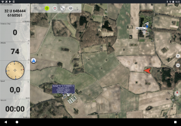
Meters अंतर मीटर, सरासरी वेग, पत्करणे, उंची इ. साठी फील्ड असलेले ट्रिपमास्टर)
GP जीपीएक्स / केएमएल / केएमझेडची निर्यात
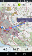
• शोधा (ठिकाणांची नावे, पीओआय, रस्ते)
Map नकाशा दृश्य आणि ट्रिपमास्टरमधील सानुकूल डेटा फील्ड (उदा. वेग, अंतर, होकायंत्र ...)
Way वेपॉइंट्स, ट्रॅक किंवा मार्ग सामायिक करा (ईमेल, व्हॉट्सअॅप, ड्रॉपबॉक्स, फेसबुक मार्गे ...)
Lat लॅट / लॉन, यूटीएम किंवा एमजीआरएस / यूएसएनजी (लष्करी ग्रीड संदर्भ प्रणाली / यूएस नॅशनल नेटवर्क) मधील समन्वय पहा.
Statistics आकडेवारी आणि उन्नत प्रोफाइलसह ट्रॅक रेकॉर्ड आणि सामायिक करा
Map नकाशा फिरवा (ट्रॅक आणि ट्रॅक)
Long नकाशावर दीर्घ-क्लिक करून उंची आणि अंतर मिळवा
• ट्रॅक प्लेबॅक
Custom सानुकूल नकाशा सर्व्हर जोडा
• आणि बरेच काही ...
प्रोसाठी उपलब्ध: (अॅप-मधील खरेदीसाठी उपलब्ध असलेली वैशिष्ट्ये)
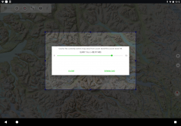
Line ऑफलाइन वापर - मोबाइल कव्हरेज आवश्यक नाही. रोमिंग शुल्क नाही!
OF ऑफलाइन वापरासाठी नकाशेचे सुलभ आणि द्रुत वस्तुमान डाउनलोड (Google आणि बिंग नकाशे वर लागू होत नाही)
• मार्ग तयार आणि संपादित करा
Navigation मार्ग नेव्हिगेशन (पॉइंट-टू-पॉइंट नेव्हिगेशन)
GP जीपीएक्स / केएमएल / केएमझेड आयात / निर्यात करा
Way वेपॉइंट्स आणि ट्रॅकसह अमर्यादित
Other इतर नकाशे सर्व्हर जोडा
• जाहिराती नाहीत
ऑफलाइन वापरः
सर्व प्रदर्शित नकाशा बॉक्स कॅशेमध्ये ठेवलेले आहेत. मोठ्या भागात कॅश करण्यासाठी, आपल्याला प्रो वैशिष्ट्ये खरेदी करण्याची आवश्यकता आहे.
हायकिंग, दुचाकी चालविणे, कॅम्पिंग, क्लाइंबिंग, घोड्यावर स्वार होणे, स्कीइंग, केकिंग, शिकार करणे, ऑफडॉड 4 डब्ल्यूडी टूर्स किंवा सीआर रेस्क्यू (एसएआर) या बाह्य क्रियाकलापांसाठी या नेव्हिगेशन अॅपचा वापर करा.
डब्ल्यूजीएस dates84 तारखांसह रेखांश / अक्षांश, यूटीएम किंवा एमजीआरएस / यूएसएनजी स्वरूपात सानुकूल मार्गबिंदू जोडा.
जीपीएक्स किंवा Google अर्थ केएमएल / केएमझेड स्वरूपनात जीपीएस वेपॉइंट्स / ट्रॅक / मार्ग आयात / निर्यात / सामायिक करा.
मोबाईल कव्हरेज नसलेल्या क्षेत्रांसाठी प्री-लोड विनामूल्य नकाशा डेटा (प्रो फंक्शन).
टिप्पण्या आणि विनंत्या swedenmaps@atlogis.com वर पाठविल्या जातात
आमच्या इतर मैदानी नेव्हिगेशन अॅप्सवर एक नजर टाका:
https://play.google.com/store/search?q=atlogis
++ आम्ही वापरकर्त्याच्या क्रियाकलापाचा मागोवा घेत नाही किंवा वापरकर्ता डेटा संकलित करीत नाही! ++
Sverige Topo Kartan - आवृत्ती 7.8.0
(16-04-2025)
Sverige Topo Kartan - एपीके माहिती
एपीके आवृत्ती: 7.8.0पॅकेज: com.atlogis.swedenSverige Topo Kartan ची नविनोत्तम आवृत्ती
इतर आवृत्त्या


 4.63
4.63


 3.55
3.55


त्याच श्रेणीतले अॅप्स

आपल्याला हे पण आवडेल...


